ISRO sets record by successfully launching 20 satellites in single mission
Friday 24th of June 2016
Sharing is caring
They include satellites belonging to the United States, Canada, Germany and Indonesia. The launch took place from the Sriharikota space centre off India's east coast. Observers say it is a sign that India is emerging as a major player in the multi-billion dollar space market.
The record for the most number of satellites launched in a single mission belongs to Russia, which sent up 37 satellites in 2014. The US space agency Nasa launched 29.
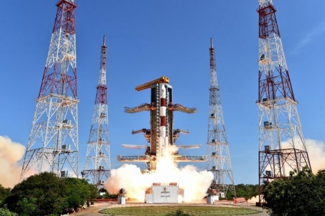
As Indian scientists and government ministers kept a close watch, the rocket carrying 20 satellites blasted off from the launch facility in Andhra Pradesh state.
They include an Indian cartographic satellite as well as those belonging to the country's universities and international customers - 13 satellites are from the US, including one made by a Google-owned company.
Points to remember
- The primary satellite in this mission was India’s latest earth observation satellite Cartosat-2. It was PSLV’s 35th continuous successful launch of its total 36th flight.
- Other 19 satellites were from countries US (13), Canada (2), Germany (1) and Indonesia (1). It also had two satellites from Chennai’s Sathyabama University and College of Engineering, Pune (COEP).
Cartosat-2
- Cartosat-2 satellite is similar to the earlier Cartosat-2, 2A and 2B. It will be placed a 505 km polar Sun Synchronous Orbit (SSO)
- It will be used for detailed mapping and other cartographic applications as well as applications in Land Information System (LIS) and Geographical Information System (GIS).
- The images sent by Cartosat-2 will be used for drawing maps, urban and rural applications, coastal land use and regulation, road network monitoring and water distribution.
Other satellites launched
- LAPAN A3: It is Indonesian micro-satellite which will be used for earth’s magnetic field monitoring and surveillance purpose.
- BIROS: It is German satellite to be used for remote sensing of high temperature events.
- SKYSAT GEN 2-1: The micro-satellite developed by Google’s subsidiary company Terra Bella’s. It will be used for earth imaging.
- 12 Flock-2P Earth imaging satellites: These are earth imaging satellites from United States.
- M3MSAT (Maritime Monitoring and Messaging Microsatellite): It is Canadian micro-satellite that will be used for study and collection of automatic identification system signals from low earth orbit.
- GHGSat-D: It is Canadian earth observation satellite. It will be used for measuring the atmospheric concentration of greenhouse gases (GHGs) especially Carbon Dioxide (CO2) and Methane (CH4).
- Sathyabamasat: The satellite has been designed and built by Chennai based Sathyabama University. The satellite aims to collect data on greenhouse gases (GHGs).
- Swayam: It has been designed and built by College of Engineering, Pune (COEP). It will be used to provide point to point messaging services to the HAM (amateur radio) community.
Comment
The mission was historic double record for the ISRO’s workhorse PSLV C34. It has inserted a record number of 20 satellites into space and also has proved to be reliable for double ignition while in space to take multiple satellites into different orbital heights in a single mission. Thus, PSLV in its category proves to be one of the most sophisticated and highly versatile launch vehicles in the world in its class.
Sharing is caring
Related Post
US Bioengineer Professor Frances Arnold becomes first woman to win $1.1 million technology prize
Microsoft Signs Agreement - Acquire LinkedIn for $26.2 billion
‘Digi Yatra’ initiative to make flying simpler
Industries found illegally dumping e-waste near Ramganga River to pay Rs 1 lakh
India becomes world’s fifth largest military spender
The first female mayor of Rome, Virginia Raggi